
Making Remote Sense
- Category: Archived News
- Published: Monday, 03 February 2014
Arctic and oilsands data collection without physical contact
 On what was undoubtedly an unbearably cold and miserable day in the late 1840s in the Canadian Arctic, the last British voyagers on the HMS Erebus and HMS Terror succumbed to pneumonia, hypothermia, lead poisoning or some other unpleasant end, as did the rest of the 128-man crew of Capt. Sir John Franklin’s ill-fated and final expedition to traverse the last unnavigated section of the Northwest Passage.
The exploration of Canada’s northern, hostile wilderness has historically involved danger, hardship or, at the very least, a great deal of human effort.
Fortunately, according to LOOKNorth executive director Bill Jefferies, contemporary exploration and monitoring of the Arctic and oilsands regions are supported by a rapidly evolving array of remote-sensing technology that augments on-site human presence, or reduces or removes the need for human presence altogether, to attain high-quality, valuable data.
“Particularly over the past several years, there has just been a proliferation of new and better sensors,” says Jefferies, whose C-CORE-hosted centre for commercialization and research in St. John’s supports responsible, sustainable resource development in the northern regions of the country through its technology validation program.
“Whether we’re talking about radar, whether we’re talking about optical, whether we’re talking about some of the geophysical systems and potential field measurements like magnetic, electromagnetic and gravity, those are all basic areas that Canadian technology has been very good at for a long time.
“Now what is happening is you are getting more accurate sensors. You’re getting smaller, lighter and cheaper sensors, much better spatial resolution with the sensors, and much better accuracy and precision of the measurements they make. That has really expanded drastically in the last few years.”
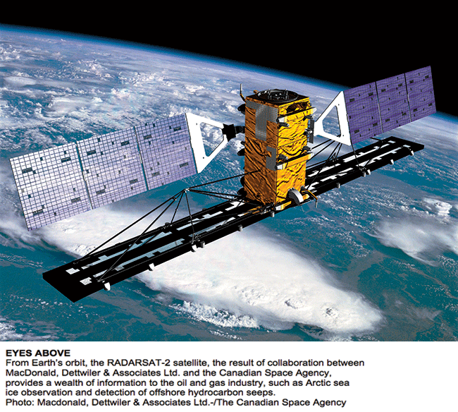
In a sun-synchronous orbit approximately 800 kilometres above the Earth, RADARSAT-2 is a synthetic aperture radar and C-band satellite system that works independent of both weather and light, sending a pulse to the planet’s surface that bounces back and provides a plethora of imagery for data analysis.
Michael Nemirow, vice-president of energy and mining with MacDonald, Dettwiler & Associates Ltd. (MDA), says radar is very effective at identifying oil on water, among other things, and therefore MDA offers routine monitoring for all offshore operations to ensure companies take corrective action if there is ever any spillage.
“If there is an incident, this information is used to identify the extent and area of the oil so [the company] can take the necessary actions to contain it,” he says. He adds that same capability allows MDA-owned RADARSAT-2 to provide valuable information during the exploration phase of offshore oil and gas operations by detecting naturally occurring hydrocarbon seepage coming up from formations below the sea floor.
“It can help them identify where they want to take further exploration action because of the cluster of seeps we identify from space.”
Historically, remote sensing involved the application of some fairly expensive programs, but Jefferies says those costs have declined dramatically in recent years.
“It used to be that if you wanted to do a job in the Arctic, you basically had to pay the whole shot. Whether it was deployment of the airplane or deployment of the satellite, the cost was often borne by a few or often a single viewer. Now I think that is changing. Systems are becoming smaller, they’re more transportable, and you have a broader customer base that is interested in it.
“There are a couple of really neat sensors that we are working with right now,” he says, noting Calgary-based Sky Hunter Corporation’s plane-mounted ion sensor. Jefferies says the technology is unique, and the fact that it detects oil and gas deposits offshore and onshore is likely going to make it a highly sought-after technology for the industry.
“I think the potential is there because it is perceived as being a money-maker.”
“SNIFFING OUT” HYDROCARBON RESERVOIRS
Russ Duncan, Sky Hunter director and co-founder, says his company deploys sensory equipment on small airplanes that can detect negatively charged hydrocarbon particles that determine areas where companies would want to search for possible oil and gas assets below the earth.
“In a reservoir, it fills over geological time, but there is a small degree that always comes through the caprock.... And when it comes through the caprock it is like a refinery—[the molecules] get cracked, and when the hydrocarbons get cracked, they pick up a negative charge.”
Duncan says the positively charged ionosphere pulls those negatively charged particles into the atmosphere, and his company’s remote-sensing technology uses three sensors to detect these microseeps, helping locate hydrocarbon deposits for the oil and gas industry.
“It’s another layer of information, but it’s very important because it is a direct hydrocarbon indicator.”
According to Duncan, Sky Hunter technology cannot determine the depth of hydrocarbons, but it can indicate the existence of hydrocarbons in a particular area two out of three times. With “minor tweaking,” he says, the remote-sensing technology is becoming increasingly more accurate as well.
“We might put multi-sensors on the plane and get multi-layers of data,” he says, adding Sky Hunter is also looking at the possibility of placing its remote-sensing equipment onto unmanned aerial vehicles (UAVs), and companies exploring off the east coast have expressed interest in the availability of such an application. He expects to see microseep-detection technology on a UAV by the end of 2014.
“What we need to do is probably lighten up some of the components, but that can be done. That’s just an engineering sort of thing. We’re pretty keen on doing that.”
Sky Hunter just finished a survey for four companies in the oilsands, and Duncan says remote sensing is increasingly important for the energy sector in northern Alberta. He says the use of remote sensing as opposed to physical land disturbance in the oilsands is preferable not just for economic reasons, but ecological ones as well. “Given the fact our maps show where not to go, there could be a lot of places left undisturbed from dry holes that do not help anybody.”
REMOTE SENSING FOR ENVIRONMENTAL IMPACTS
In December, the Alberta Biodiversity Monitoring Institute (ABMI) released the first ever report on the status of biodiversity in the Athabasca oilsands region. It measures the localized human footprint from industrial operations, such as mining and in situ oilsands production, and correlates that with declining rates of species within specific areas.
Jim Schieck, science co-director at ABMI, says satellite and airborne remote sensing played an integral part in determining characteristics of the landscape to accompany in-field data collection on 350 species in the oilsands region for the biodiversity report.
“That remote sensing information talks about the type of human development and footprint in the area. This is compared with species information to look for relationships,” he says. “By comparing remote-sensing information to on-the-ground species information, we see how each species responds to different habitat types and to the footprint in those habitats.”
According to Jefferies, remote-sensing technology is increasingly important for environmental monitoring and stewardship efforts in the oilsands. He points to Edmonton-based Boreal Laser Inc., which is developing laser systems that can detect a variety of greenhouse gases.
“I think that is quite exciting, obviously, because of the general public’s concern about the increasing presence of greenhouse gases in the atmosphere. I think it is fair to say there is probably a lot of angst and concern that is not well founded, so this not only provides a monitoring capability, but also a transparency capability.”
Hamish Adam, Boreal Laser chief executive officer, says his company’s technology consists of lasers that are sensitive to gases such as CO2 and carbon monoxide. The instrument shines the laser beam through the air to a reflector and receives a signal proportional to the amount of gas along the measurement path.
“We’re using a technique called infrared spectroscopy. The wavelength of the laser coincides with the wavelength at which the gas we’re interested in measuring absorbs light,” he says. “When we shine this laser beam through the air, and there is methane [CH4] in the air, then the methane absorbs some of the laser beam and reduces the amount of energy in the laser beam that makes the journey to the reflector and back to the instrument.”
In regard to oil and gas operations, Adam says the main use of Boreal Laser technology to date has been providing CO2-monitoring equipment to Shell Canada Limited’s Quest carbon capture and storage (CCS) project near Redwater, Alta.—which will sequester CO2 from the nearby Scotford Upgrader—and detecting hydrogen sulphide leaks at several sour-gas-processing facilities in the province.
“We’re working directly with Shell on their Quest project to do long-term, baseline monitoring of carbon dioxide levels at the [CCS] site before they start injecting CO2 into that subterranean facility in late 2014.”
Adam says Boreal Laser’s technology is configured most commonly for ground-based measuring with a battery-powered instrument mounted on a tripod and paired with a distant reflector array. The technology is also available for airborne applications.
“Using our equipment, owners and operators of natural gas pipelines and service companies that provide aerial service to pipeline companies fly our equipment on their helicopters as they fly along the pipelines, measuring the ambient concentration of CH4. When the ambient increases significantly over a short period of time, it is typically an indication of a plume of methane resulting from a leak in the pipeline.”
According to Adam, Boreal Laser is currently working on miniaturizing its technology in order to place it on UAVs, which he says would be ready for demonstrations by mid-2014. Boreal Laser is also developing versions of its technology that measure toxic hydrocarbons, volatile organic hydrocarbons and polycyclic aromatic hydrocarbons, using quantum cascade lasers.
“So what I see for the oilsands is Boreal Laser delivering instruments that can measure not just greenhouse gas emissions, but also the emissions of those toxic hydrocarbons. We would do that using ground-based instruments that can do permanent, fixed monitoring around tailings ponds or in the vicinity of tailings ponds.
“Particularly for deploying in remote areas of the oilsands and the Arctic, the opportunity to fly our equipment on UAVs in order to do more extensive surveys is very attractive.”
MULTISPECTRAL MONITORING
Terra Remote Sensing Inc., of Sidney, B.C., uses an integrated airborne system of various sensors, including light detection and ranging (LiDAR, an optical remote sensing technology), digital imagery, hyperspectral and positioning systems for an ongoing project to collect imagery data on a large contiguous block of the Peace–Athabasca Delta located downstream from industrial developments.
The hyperspectral camera is a passive sensor that measures visible-to-near infrared portions of the electromagnetic spectrum without going into a thermal range, splitting the spectrum into as many as 492 bands, says Taylor Davis, LiDAR applications specialist at Terra Remote.
Combined with a spectral library of a certain condition attained through ground sampling, Davis says the hyperspectral sensor can measure deviations from what should be expected with conditions in a particular area.
Much of the information provided on the Terra Remote system focuses on both form and function of the landscape, which applies to the landform surface as well as the vegetation that covers it. Davis says the benefit of this approach is that it maps path flows within the landscape and addresses changes to both the structure and health of vegetation along these paths.
“The information is intended for those who are concerned with the broader impact of the extraction activities, particularly in downstream off-site areas where there could be potential convergence of contaminants.”
According to Davis, the desired outcome of Terra Remote’s data collection is a greater understanding of the actual impact that oil and gas activities have in the downstream region, which could lead to more effective development of resources for monitoring and migration. Because wetlands are very sensitive gradient landforms, he suggests sensors can monitor environmental changes through changes in locally adapted vegetation.
Davis says activities in the oilsands-impacted areas are uniquely suited to remote sensing, in part because licensees are required to return the landscape to a level that replicates ecological functioning once they have finished with extraction and reclamation.
“The data that are collected with our system allows for the characterization of the vertical and horizontal landscape structure as well as species composition. These data can be used to develop a metric for post-mining reclamation. In addition, the affected wetland network can be mapped for future reconstruction.”
KEEPING ICE TROUBLES AT BAY
In the Arctic, Jefferies says, Canada is a world leader in ice mapping through remote sensing, with MDA’s RADARSAT program largely designed with Arctic ice in mind.
“Really, RADARSAT is the default standard in the world for doing operational ice mapping. Whether that’s producing daily charting, determining the ice dynamics in a region or how to predict what is going on, all those are aspects that apply to the Far North.”
Due to the broad area the system can cover, the fact it operates regardless of weather and because of the positioning of the satellite’s orbit, Nemirow says RADARSAT-2 is a reliable tool for monitoring ice and managing offshore oil and gas exploration and production.
“We are able to provide oil companies and service companies with information about the ice edge or ice movement, icebergs or pressure areas that are occurring. That information is used to keep their operations safe.”
Launched in 1995, RADARSAT-1 functioned for 17 years before finally going silent this past year. Fortunately, RADARSAT-2, which was launched in 2007, still provides a range of remote-sensing services.
In 2013, the federal government announced a $706-million contract with MDA to build, launch and provide initial operations for a new RADARSAT Constellation mission before the end of the decade.
“That will only serve to improve the high level of service that we offer our customers today,” Nemirow says, adding MDA, based out of Richmond, B.C., provides optimized imagery from RADARSAT for ships travelling though troubled waters, as well as nearly real-time satellite information so companies can determine how they want to operate in a northern sea environment.
“They can assess where the ice edge is or if there are any hazards that they need to consider in the operations that are occurring offshore.”
One of the programs LOOKNorth currently funds investigates some of the extreme ice features in the North, which Jefferies says includes areas of high deformation that would be very difficult for a ship to navigate or for an offshore platform to withstand.
Perhaps if modern remote-sensing technology had been around 170 years ago, the HMS Erebus and HMS Terror would not have become icebound in the Victoria Strait, and Franklin’s final expedition might have safely traversed the Northwest Passage.
Of course, remote sensing possibly could have rendered such a dangerous voyage of discovery unnecessary in the first place.
Robot Boat Could Revolutionize Tailings-Pond Monitoring, Say Developers
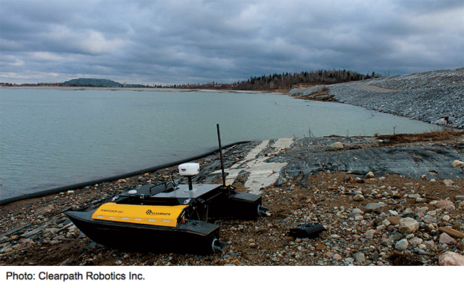
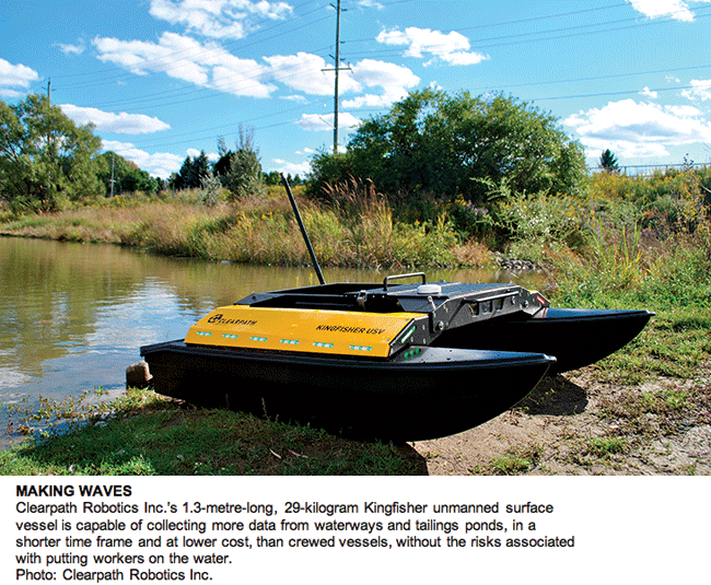 Although small in size, the robotic Kingfisher bathymetry vessel could be the next big thing in monitoring and management of oilsands tailings ponds, says the company developing the machinery.
Working with LOOKNorth’s technology validation program, Blyth Gill, Kingfisher’s commercialization manager at Clearpath Robotics Inc., based in Kitchener-Waterloo, Ont., says by summer 2014 his company’s unmanned survey vessel would be providing topographic information of the bottom of tailings ponds in northern Alberta.
According to Gill, in a tailings pond application, Kingfisher “ties together” its GPS and sonar capabilities to provide readings of the exact position of the pond bottom, which is constantly changing as new materials are added from industrial mining operations.
“In understanding the depths and the amount of volume within these ponds, you can calculate how much sediment has gone in there, how much water is in there, as well as calculating the lifespan left of these tailings ponds. Depending on the size and what those tailings ponds are used for, they may need to be increased.”
Gill says Kingfisher is a lot more accurate than traditional methods of measuring the bottom of a tailings pond because the small robot boat can do more transect lines and collect more data than conventional survey crews riding in a larger boat. He adds that Kingfisher has sensors to measure pitch, heave and roll as it rides along, enabling triangulation of the exact bottom of the pond even if there are bumpy waters at the surface.
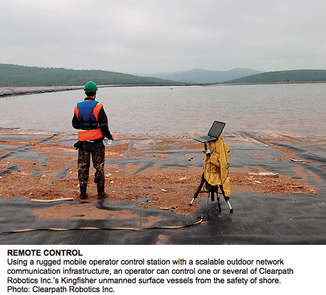
The remote-controlled boat consists of two pontoons with embedded electric jet thrusters, which Gill says gives the device a shallow-draft profile. The watercraft connects wirelessly to a base station and relays collected information from GPS and sonar sensors to the operator.
In a case study with Saskatoon-headquartered PotashCorporation of Saskatchewan Inc., the world’s largest fertilizer producer, Clearpath used the Kingfisher to map a tailings pond in Atlantic Canada. Tailings ponds are unique environments with specific safety requirements, Clearpath notes, and contain complex chemical com-positions that make taking accurate bathymetric readings difficult. Density stratification at various depths can cause sonar waves to become distorted and impede quality data collection.
In the case study, the company was able to safely collect 100 times more data in one-eighth the time and cut costs by 60 per cent. The full survey was completed in 12 hours with 89,000 usable data points collected, according to the study. By combining the data collected remotely with slime-depth measurements taken with physical probes, it was possible to determine the capacity of the tailings pond and create a bathymetric map.
In the upcoming months, Gill says, Clearpath plans to launch an “autonomy package” for Kingfisher, so an operator can preplan the boat’s course and simply observe the incoming data, intervening only if necessary.
“There is a location for a camera on board as well, so when it is beyond line-of-sight there will be that option too, in the future, to control it through a camera feed.”
According to Gill, there is a definite health and safety advantage to sending Kingfisher out on a toxic tailings pond to take measurements, as opposed to sending out an actual person in a boat. “Anytime you send somebody out on a tailings facility, it is added risk. While there are ways of doing things properly, if you could simply remove that person from the hazardous situation entirely, then everybody benefits.”
The versatility of the range of remote-sensing equipment the boat can accommodate should prove an attractive feature to companies as well, Gill suggests, as an operator could attach different sensors to the boat in order to attain whatever measurements are deemed necessary.
“This system, apart from having on-board intelligence, is also unique in the fact that you can plug and play with multiple different GPS systems, as well as sonar packages,” he says, adding that without any monitoring and control equipment on board, Kingfisher costs less than $30,000.